

Dhaka Could Turn into Rubble, and the Economy May Take a Hit from the Upcoming Tremor
Dr. Pamelia Riviere
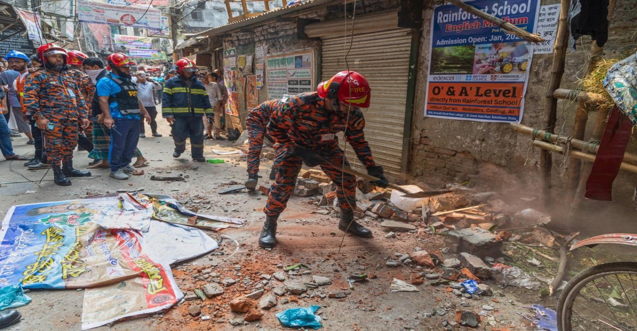
In the past 30 days, Bangladesh has experienced a total of 22 earthquakes, with magnitudes predominantly above 2, the strongest being recorded at 5.4. Notably, one earthquake exceeded magnitude 5, and six others fell within the range of 4 to 5. On a recent Thursday, a mild earthquake measuring 4.1 struck early in the morning at 6:14 am local time, with its epicentre located at a depth of 30 km in Narsingdi. This event resulted in tremors that were felt in the capital city, Dhaka, and surrounding districts. Still, fortunately, there were no reports of damage or casualties, according to tbsnews.net, citing the European-Mediterranean Seismological Centre.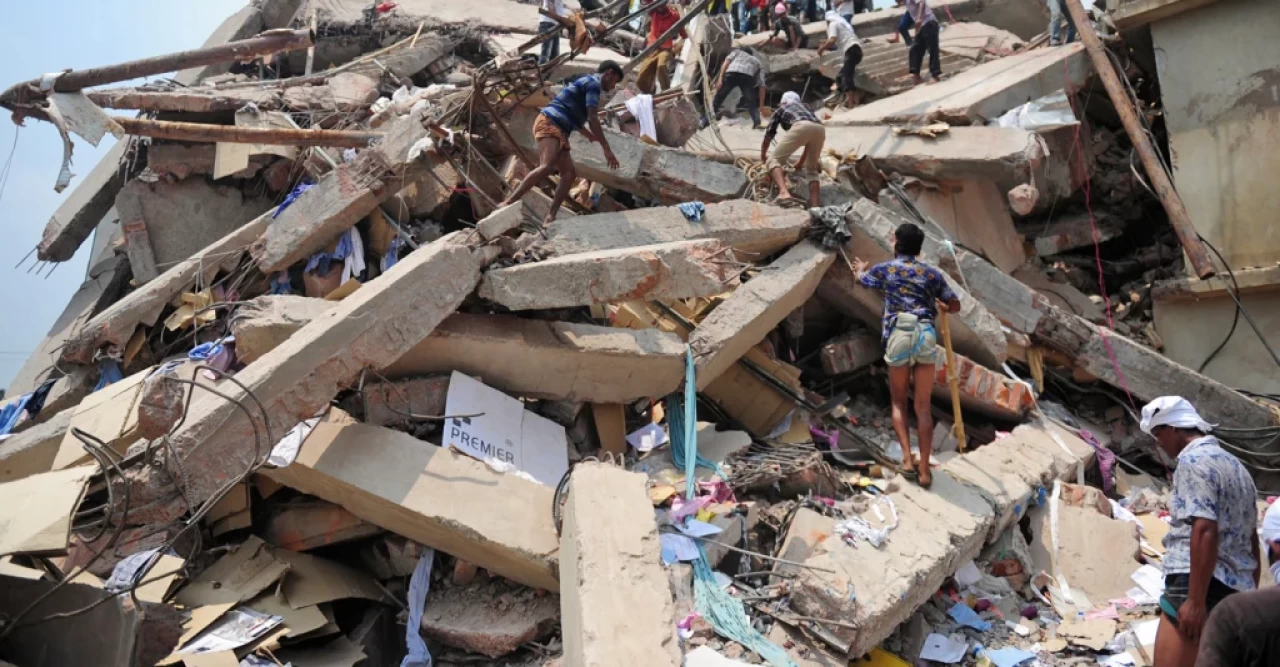 Due to the earthquake's shallow depth, the tremors experienced in Dhaka and neighbouring areas were relatively minor. Bangladesh is particularly vulnerable to significant seismic activity because it lies at the meeting point of three tectonic plates: the Indian, Myanmar, and Eurasian plates, as highlighted by The Daily Star. The previous month, a stronger earthquake with a magnitude of 5.7 resulted in the loss of 10 lives and caused extensive damage across central Bangladesh, particularly affecting Dhaka and Narsingdi. Given the region’s susceptibility to earthquakes, there is ongoing concern that a significant seismic event could devastate Dhaka and adversely affect its economy. The potential for a major quake poses substantial risks for both infrastructure and economic stability in the city.
2013 report from the American Museum of Natural History 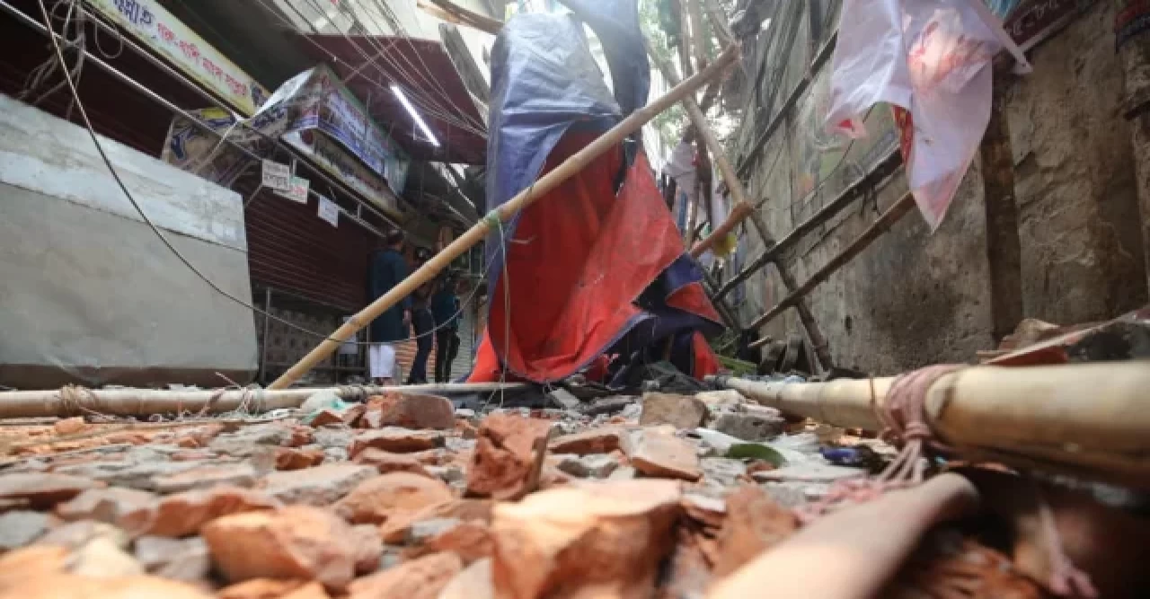 In 2013, a report from the American Museum of Natural History discussed the Dauki Fault and the seismic activity in Bangladesh. The article titled "Earthquake Risk in Bangladesh" highlighted findings from the study. I relied heavily on this report to compose my article regarding the current earthquake concerns in Bangladesh. Researchers are particularly focused on the Dauki fault system surrounding the Shillong Plateau.
They have discovered several important insights: Numerous minor faults exist along the Dauki fault system. However, project data and field studies validate the presence of a single, major fault that slopes beneath the Shillong Plateau. In reality, the vast formation known as Shillong might not actually be a plateau, but rather an anticline (a significant fold) created by the immense tectonic forces associated with this deep fault.
Geologist Leonardo Seeber has highlighted the region's high earthquake risk due to its location on tectonic plates and the presence of fault lines. He has also been involved in research suggesting that a major earthquake could shift the course of the Brahmaputra River, with catastrophic consequences for the region.
Seeber explains, “The Dauki fault is quite recent, so it remains entirely buried. Yet, we are aware of its presence because one of the largest anticlines globally is ascending above this fault.”
Scientists believe this primary fault poses the greatest earthquake risk. While smaller faults can lead to frequent seismic activity, significant earthquakes from a major fault like this one occur less often but can be destructive. The research also indicates that the fault lies closer to Dhaka than previously thought.
Geologist Humayun Akhter states, “It is crucial to pinpoint the fault’s position to evaluate seismic occurrences.” The team discovered that the angles at which the rock layers dip increased as they moved further south. “If the fault lies 10 to 20 km to the south, that implies the earthquake source is nearer to the capital city, Dhaka.” Ultimately, the researchers found that the Dauki fault is highly active. Seismic stations in the area recorded over 300 seismic incidents within a 1-2-year timeframe — including many too small for human perception — near the Dauki fault.
Akhter remarks, “This indicates that the region is highly active, and a significant earthquake could happen in the future.” Additionally, GPS stations are providing proof of an active fault. GPS data illustrate that the Shillong Plateau is shifting southward (relative to India) at approximately 8 millimetres annually. Michael Steckler mentions, “We can actually observe the plate movements using GPS.” Concurrently, to the east, the plate near the Burma Arc is shifting west toward Dhaka. In both locations, the strain results in rock folding and buckling. This strain is accumulating towards a major earthquake.
Analyzing the information collectively reveals that data from field observations, seismic stations, and GPS devices show the area’s significant vulnerability to earthquakes.
It also points to the possibility of a gigantic earthquake or “megaquake.” Seeber states, “A basic principle of seismology posits that the larger the fault, the greater the potential earthquake it can generate.” Considering the Dauki Fault, one is dealing with a structure that spans 300 kilometres in length and about 100 kilometres in width. It’s a massive structure. Hence, we anticipate a significant earthquake. The historic patterns in the region further reinforce this forecast.
Scientists currently believe that megaquakes along the Himalayas are not only feasible but also inevitable, as the Indian Plate continues to move northward beneath the Eurasian Plate. Scientists can also analyze motion and strain data around a fault to approximately estimate the intervals between earthquakes. Along the Dauki fault, the rocks are moving at an extremely slow pace, suggesting a long duration between substantial earthquakes. Sadly, this has led many individuals in Bangladesh to underestimate the danger lurking beneath the surface.
Seeber comments, “You might dismiss it and think, ‘Oh, we’ve never experienced an earthquake, so why should we be concerned?’”
Geology tells us otherwise; a fault exists, it is active, and the reason there haven’t been any major earthquakes in recent history is simply due to the lengthy intervals between them.”
Researchers are also exploring how tectonic activity interacts with the delta formed by the Brahmaputra, Ganges, and Meghna Rivers. What impact could a significant earthquake have on this river system?
The Dauki Fault
The Dauki fault passes along the southern margin of the Shillong Plateau. The plate boundary mega-thrust between the Indian and Burman plates around Bangladesh is divided into the Tripura and Arakan segments.
Certain areas are particularly at risk: the Sylhet Division and parts of Mymensingh and Sunamganj near the Dauki Fault; the central districts around Dhaka and Tangail near the Madhupur Fault; and Chittagong, along with surrounding coastal areas near the Chittagong–Myanmar plate boundary.
The Dauki fault poses a threat to Dhaka, Bangladesh, due to its proximity and the region's high seismic risk. A major earthquake along this fault could cause widespread destruction, including the collapse of many buildings and a significant loss of life, especially given Dhaka's soft soil and many unreinforced structures. The most considerable earthquake risk in Bangladesh comes from a newly discovered, hidden fault line beneath the country that could trigger a massive quake (magnitude 8.0-9.0).
This fault is perilous because of its potential size, the dense population in the area—including the greater Dhaka region—and existing vulnerabilities, such as poor building standards and weak infrastructure, which make the region even more susceptible. Hidden Fault Line: A major, concealed fault line has been identified beneath Bangladesh, stretching into parts of East India and Myanmar.
A tragedy awaits Bangladesh if the urbanization plan is not introduced quickly.
A tragedy awaits Bangladesh if an urbanization plan is not introduced swiftly. Dhaka is ranked among the world’s 20 most earthquake-vulnerable cities due to its extremely dense population and numerous dilapidated buildings, particularly in the older parts of the capital. The region has a long history of powerful earthquakes, with five major tremors recorded between 1869 and 1930, each measuring above 7.0 on the Richter scale. However, even the top geologists and scientists are unable to predict earthquakes because the processes leading to them are too complex and their timing is unpredictable. While they can identify high-risk areas and provide long-term probabilities, they cannot specify the exact time, location, or magnitude of a future earthquake.
Professor Syed Humayun Akhtar, a geologist, has stated that the government lacks earthquake preparedness and planning. "We cannot prevent earthquakes or provide advance warnings, but we can reduce their damage if we make the right decisions," he said. Professor Akhtar served as the supervisor of the Earth Observatory at Dhaka University for many years and spoke during a discussion program on bdnews24.com called Inside Out. In terms of seismic risk, Bangladesh faces a potential 9.0-magnitude earthquake, which could result in the collapse of half of Dhaka.
The country is particularly vulnerable due to its location on three tectonic plate boundaries, and seismologists warn that an earthquake of magnitude 9.0 could strike at any time. Even a magnitude 6.9 earthquake, discussed by RAJUK (Rajdhani Unnayan Kartripakkha), could cause extensive damage, potentially destroying 800,000 homes and severely impacting the lives of 20 million people, as indicated in the organization’s disaster preparedness plans.
This scenario is plausible, as earthquakes in this magnitude range can cause significant damage, especially to poorly constructed buildings in densely populated areas, leading to substantial loss of life and infrastructure.
An earthquake with a magnitude of 6.96 has the potential to cause significant damage, particularly in densely populated areas with many vulnerable structures. According to RAJUK's disaster plan, such an earthquake could destroy approximately 800,000 homes and affect around 20 million people, underscoring its catastrophic impact. While the magnitude is crucial, the actual consequences also depend on factors such as distance from the epicentre, soil type, and the quality of construction.
However, the Bangladesh government currently has no safety measures in place.
Addressing the earthquake aftermath and risk mitigation in Bangladesh
The Bangladesh government recognizes the potential threat posed by the Dauki fault and its influence on the Brahmaputra River. Given the inevitability of a significant earthquake at some point in the future, it is crucial to implement strategies to minimize the impact of such disasters. To safeguard Dhaka city and its inhabitants, effective urban planning is essential. Proactive measures can be taken to reduce the risk of catastrophic outcomes, even if an earthquake cannot be avoided. Seeking expert guidance is a vital step in this process.
The Bangladesh government can benefit from consulting with local and international geologists, as well as specialists from Japan, known for their expertise in earthquake management. Engaging in discussions about disaster preparedness and response plans is essential for strengthening Bangladesh's resilience against the frequent seismic events it faces. It is crucial to recognize that taking action now is far better than delaying initiatives until later. By prioritizing earthquake preparedness, Bangladesh can enhance its ability to manage disasters effectively during and after seismic events.
Predicting earthquakes remains a significant challenge for geologists and scientists due to the inherent complexity of the processes involved and the unpredictability of timing. While experts can identify high-risk areas and provide long-term probabilities for seismic events, they cannot specify when, where, or how powerful a future earthquake will be. One major obstacle is the lack of reliable precursors that signal an impending quake.
Although some foreshocks or "slow slip events" have been observed before significant quakes, these indications are not consistent enough to be used for accurate predictions. Additionally, the geological factors that contribute to earthquakes are multifaceted, including fault line strength, rock composition, gravity, and mantle currents—many of which remain poorly understood. The long accumulation of stress along fault lines often takes decades or even millennia, while the release of that energy occurs in mere seconds, complicating efforts to determine when an earthquake will strike.
Furthermore, making an accurate prediction requires specific information on the date, location, and magnitude of an earthquake—an impossible feat with current knowledge. Despite these challenges, scientists can assess earthquake risks through various methods. They create hazard maps that indicate the probability of seismic activity in specific regions over time. By analyzing historical and geological data, long-term forecasts can be formulated to identify areas that may experience large earthquakes. Additionally, early warning systems have been developed to detect seismic waves once an earthquake starts, providing alerts that can give people a few seconds to tens of seconds of advance notice before shaking reaches distant areas.
Recommendation
Professor Humayun Akhtar has delineated three primary components of seismology. The first component is earthquake geology, which examines the mechanisms by which earthquakes occur and the processes through which seismic energy is stored within the Earth's crust. Seismologists analyze fault lines and the locations of geological structures to enhance understanding of these phenomena. The second component is earthquake engineering, which focuses on the design and construction of above-ground structures to ensure they are resistant to seismic activity. Considerations related to earthquake-resistant design are critical, particularly to guarantee the longevity and safety of buildings over a span of 100 years. The third component is earthquake physics, where specialists investigate the seismic waves generated during earthquakes, alongside their impact on rock formations and geomorphological changes. Professor Akhtar emphasizes the necessity of consulting experts from these three disciplines when developing plans to mitigate earthquake hazards. Given the current lack of proactive measures by government authorities to prepare for potential disasters, it is advisable for individuals to take personal responsibility for their safety. One practical recommendation is for residents in earthquake-prone areas to consider temporary relocation, thereby safeguarding their lives during periods of increased risk.
Concerns are growing about the potential for a significant earthquake in Bangladesh, as citizens brace themselves for what could be a challenging situation. Experts highlight that the nation may not be fully prepared to manage the aftermath of such an event. Preparing for this possibility is essential to minimize panic and ensure safety for all.
The writer is a freelance analyst.


.webp)